Mt Pinatubo Eruption - Phillipines 1991
|
|
INTRODUCTION:
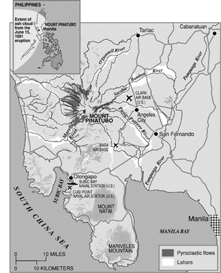
Mount Pinatubo is located on destructive boundary between the Philippine and Eurasian plate. Some rock from the Eurasian Plate melted when it subducted under the Phillipine Plate, and rose up into Mount Pinatubo, the composite volcano. Mount Pinatubo was a dormant volcano until it's 1991 eruption, located in Tri-Cabusilan Mountain Range, in the Phillipines (an LEDC (Less Economically Developed Country)). Before 1991, very little was known about Mount Pinatubo – it was heavily eroded and covered in forests. |
Causes and Information of the 1991 Eruption:
|
On July 5th 1990 the 7.7 Luzon Earthquakes occurred,
which struck 100km northeast of Mount Pinatubo. Some scientists say this was cause of the eruption. On 2nd April 11991, Mount Pinatubo had awoken and activity hadbegun. As day of eruption came closer, it was clear some volcanic activity was imminent and the area around it was hastily evacuated. Sulfur dioxide rose from 500 to 5000 tons a day over 2 weeks before eruption, implying the rise of magma beneath the Volcano. When the sulfur dioxide decreased, however, it was thought that the degasing of magma had been blocked, which builds up pressure. In early June 1991, tilt meters showed that Mount Pinatubo had begun to inflate because of the building magma pressure. The built up charged magma is what caused the explosions. If scientists had not warned of an eruption, the death toll would have been much higher. |
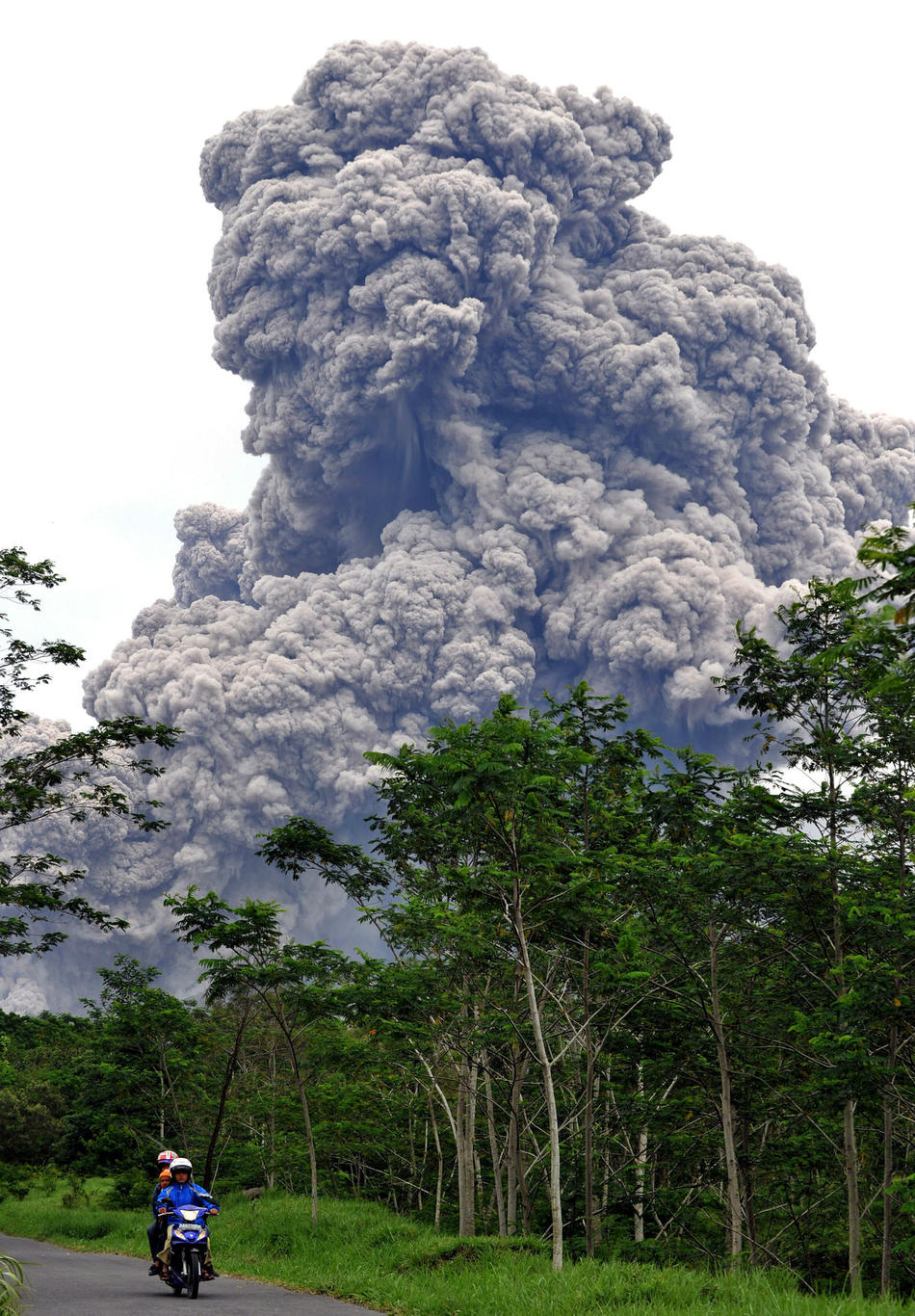
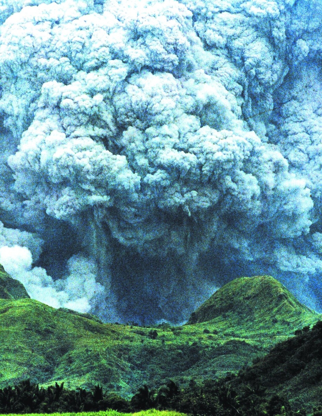
The first magmatic eruption was on the 12th June 1991,
generating a 19kn high ash column over volcano. Lava, gas and ash came out of Mount Pinatubo Density of the ash column increased until it could no longer support its own weight. The ash column collapsed on itself and turned into pyroclastic flows. Multiple flows travelled down four river valleys dissipated up to 7km from the summit. The next day, June 13th, other eruptions hurled ash columns up to 24km high, and ash ended as far as Vietnam, Cambodia and Malaysia. On June 15th 1991, the Typhoon Yunya struck the island, the same day the ash column reached 34km. Pyroclastic flows mixed with the monsoon rain and ash deposits, creating large destructive lahars. Each year, the typhoons come to the island, recreating the lahars and causing damage to infrastructure. |
|
Effects of the Eruption:
Social:847 people died from the vocanic eruption - 300 from collapsing roofs, 100 from lahars, and the rest mainly from diseases, such as measles, in the temporary and very supply-limitted evacuation centres.
184 people were injured, and 23 are still missing up untill today. 1 million people were temporarily displaced from their homes, while another 1.2 million people, due to a lack of money to rebuild or buy a new house, had to immigrate to poor towns in Manlia. Overall, 58,000 people had to be completely evacuated from a 30km radius of the volcano for a temporary amount of time. |
Economic:The Phillipines's economy was greatly affected from the volcanic eruption. 650,000 workers lost their jobs, putting stress on families to earn money and support themselves. $700 million dollars worth of infrastructure was lost, and 10 billion pesos were needed to repair and recover from the eruption. The reconstruction took 7 months.
The Manlia airport had to be temporarily closed due to falling ash, cutting down access to the Phillipines, and potentially causinf tourism rates over there to decline while the erutpion was taking place. Electricity went off, water was contaminated, and telephone links were cut, causing many businesses to shut down. Bridges and roads were also destroyed and needed replacing, making transport around the area difficult. Farmland was destroyed by falling ash and pumice, making it unusable for years. The 1991 harvest was also destroyed. This decreased the Phillipines exporting income from crops significantly. |
Environmental:When ash cleared after the eruption, it revealed a dramatic change to the appearance of the volcano. Globally, there was enough ash produced to influence global temperatures for two years, decreasing it by around 0.5 degrees Celcius.
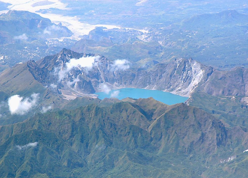
River bank erosions and undercut bridges were caused from lahars and ash. Furthermore, heavy rainfall from the Typhoon Yunga, which mixed with ash from the eruption, caused buildings and other infrastructure to collapse. When the magma chamber of Mount Pinatubo exploded outwards, it also collapsed inwards, forming a Caldera. After 7 months, this Caldera filled with rain water from monsoons and formed the Pinatubo Crater Lake. While this became a popular touristIn 2001, scientists began to drain the lake in fear it may overflow, causing mudslides down the mountain. This process was very difficult and costly to carry out. |
Predicting:
Mt Pinatubo was not being monitored until the 3rd of April 1991.
The United States Geological Service helped to predict the disaster.
Seismometers and tilt meters were put into place, checking the inflation of Mt Pinatubo.
Thanks to their accurate predictions and observations, 75,000 people were evacuated a few days before the eruption occured, saving many lives.
What they did not do, and could have done, however, was set up permanent monitoring points or use satellite images to
look upon volcano site for changes in land surface. This would help predict future eruptions as well.
Preventing:
A few days prior to the firstmajor eruption, 75,000 people were evacuated up to a
30km radius. USA air force helicopters helped, preventing many lives from being lost. There were also alert systems put into place to warn citizens of the eruption.
Temporary government shelters were put up, although some were lacking supplies, causing many people to die while at these asilems, mostly from untreated diseases like the measels.
What was not done, and the government could have done to save more lives, however, was place strategies for long term aid and
disease control in evacuations prior to even knowing that a natural disaster was about to occur.
Preperation:
Evacuation camps were quickly built for refugees. Long and short term aid was organized, especially from the Red Cross and the United States, a few days prior to the eruption.
Meanwhile, Scientists kept on the lookout for warning signs like large amounts of gas and steam cpming out of Mt Pinatubo.
What they did not do, and could have done, however, was have stored medical, food and water supplies before they even knew Mount Pinatubo would erupt; the rushed preperation caused very basic facilities and supplies at the refugee camps.
